
TAMPA, Fla. (WFLA) — After a 60 day gap between Danielle and the last named storm, Colin, the 2022 hurricane season seems to be finally coming alive. This is likely only the beginning as a more favorable pattern for tropical systems is in the forecast for next week.
But after several hyperactive hurricane seasons in a row, this season has certainly been lackluster so far, especially considering the preseason forecasts of a very active hurricane season ahead. So far this season has racked up only 8% of the normal Atlantic accumulated cyclone energy and there have been only four named systems — compared to 16 by now in 2020. Those long-range forecasters had good reason to believe that 2022 would be a busy season because all of the overarching climate conditions seemed to be lining up and all those expectations have indeed been verified.
Moderate La Niña conditions have been persistent in the Pacific Ocean – typically associated with active Atlantic seasons. La Niña is defined by cooler than normal waters in the Equatorial Pacific which typically means lighter wind shear in the Atlantic. Pacific Ocean Temperature Anomalies Sept 1st 2022 / WFLA When you compare a La Niña to an El Niño year it becomes clear that La Niña’s are significantly more active, producing 3-times the number of hurricanes over the past 30 years.
Comparison of La Niña and El Niño seasons over the past 30 years. An equal number of years were considered for both. The result: La Niña produced almost 3X the number of hurricanes.
/ WFLA Also this summer, the African monsoon – spitting tropical waves into the far eastern Atlantic – has been robust. And tropical Atlantic water temperatures have been very warm – the 6th warmest on record. It should be busy, but it’s not.
Why? The simple answer is that the weather pattern has not been cooperating. You can have perfect climate signals, but if the prevailing weather pattern is hostile, fledgling systems get knocked down before they have a chance to develop. For a slightly more in-depth answer, you can find a clue by looking at the Atlantic sea surface temperature departures from normal.
While it is warm in the deep tropical Atlantic, what really stands out is the record-breaking marine heatwave in the North Atlantic and the cool tongue of water in the eastern subtropics (north of the Cape Verde Islands). Sea surface temperature anomalies Atlantic Ocean Sept 1 2022/ WFLA Clearly, something is going on in the North Atlantic. The surface ocean temperatures are up to 14 degrees above normal.
This odd distribution of heat is clearly at least a part of what is throwing the Atlantic Tropical season off-kilter. Now typically blobs of ocean heat and cold are caused by prevailing weather conditions. And while the ocean temperatures themselves can feedback on and impact the atmospheric pattern, the weather patterns are the determining factor.
In other words, the prevailing weather pattern this summer has likely intensified the North Atlantic Ocean heatwave – so the heatwave is a symptom of what is disrupting the Atlantic hurricane season. In an active hurricane season, the textbook pattern would be for a sprawling high-pressure system – sometimes called the Bermuda high – to be centered across the subtropical Atlantic. That type of system, pictured below, helps guide tropical waves and storms westward toward the US.
It also blocks the jet stream – and associated wind shear and dry air – in the North Atlantic from invading the tropics. Idealized pattern for an active Atlantic Hurricane Season/ WFLA But this textbook pattern has not been in place this summer – far from it. Instead, the tendency has been for the high to be much smaller and further north.
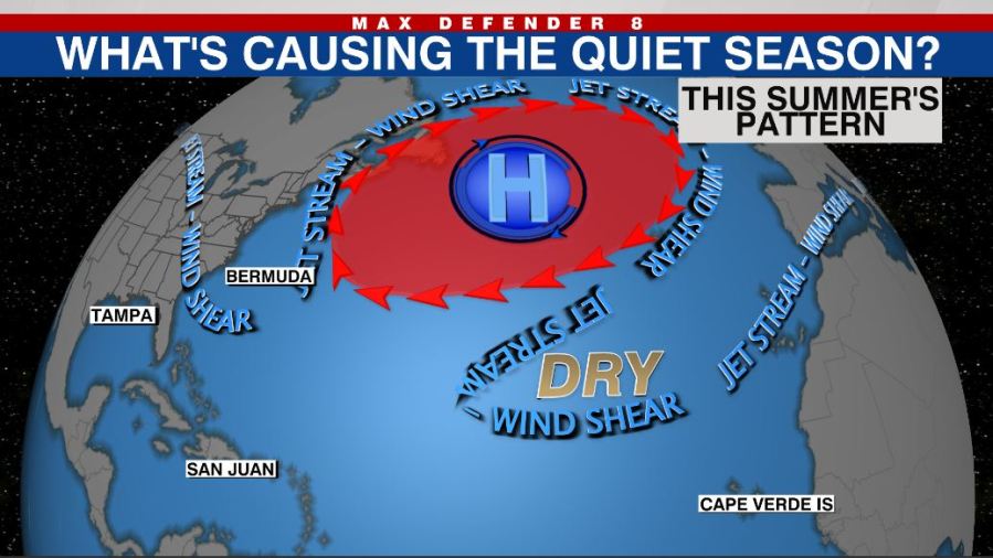
This has helped fuel the ocean heat wave. And the position of the high has enabled something called wave breaking. This is essentially when the jet stream becomes elongated north to south and unstable, with pieces breaking off at times.
Generalized visual of the 2022 summer pattern Essentially the absence of a strong, broad high pressure and displacement of the high, has allowed the jet stream and wind shear to weave around the high and infiltrate the tropical Atlantic. The introduction of excess dry air and wind shear has been enough to stop tropical disturbances before they can develop. But that may be about to come to an end.
The computer models show signs of a stronger subtropical high-pressure next week and hints of a storm moving west from Africa – a pattern more typical of the peak of hurricane season. What we do not know is how long this favorable high-pressure ridge pattern will last. But if it does continue, get ready for a busy next few weeks.
After all, we still have two-thirds of the hurricane season in front of us. In September, about 50% of major hurricanes form so we must stay vigilant. NOAA/ WFLA.
From: wfla
URL: https://www.wfla.com/weather/climate-classroom/the-reason-behind-the-slow-hurricane-season-and-whats-next/