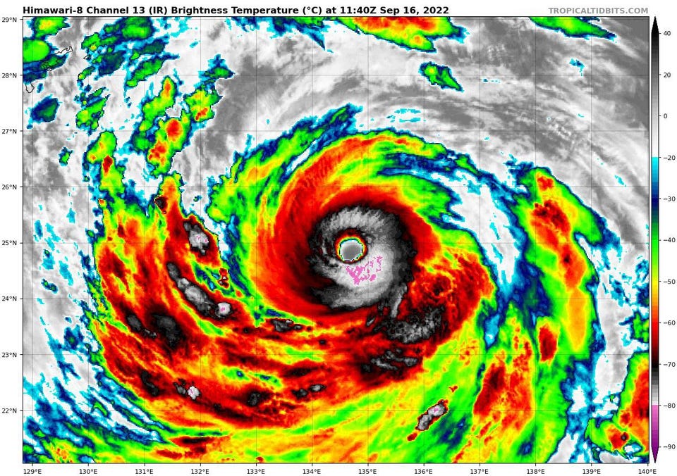
Science Super Typhoon Nanmadol Threatens Japan As Tropical Storm Fiona Lurks Closer To Home Marshall Shepherd Senior Contributor Opinions expressed by Forbes Contributors are their own. Following New! Follow this author to stay notified about their latest stories. Got it! Sep 16, 2022, 09:57am EDT | New! Click on the conversation bubble to join the conversation Got it! Share to Facebook Share to Twitter Share to Linkedin Satellite imagery shows a well-defined Super Typhoon Nanmadol on September 16th, 2022 Tropical Tidbits website The tropics are active in the Atlantic and Pacific Basin.
As I type this, a super typhoon threatens Japan. Meanwhile a tropical storm is lurking in the Atlantic Ocean just to the east of the Lesser Antilles and Puerto Rico. Super Typhoon Nanmadol has an ominous track prediction – across the entire length of mainland Japan.
Tropical Storm Fiona could possibly intensify as it approaches the islands. After that point, there is significant uncertainty with its track. Here’s the latest on both storms.
Forecast track for Super Typhoon Nanmadol Joint Typhoon Warning Center It is instructive to define the term “Super Typhoon. ” A typhoon is the same type of storm as a hurricane but is located in the Northwest Pacific Ocean. The storm is designated as a Super Typhoon if the maximum sustained winds exceed 149 mph.
The Joint Typhoon Warning Center (JTWC) upgraded Nanmadol to one earlier this morning. The latest forecast track (above) shows the storm making a hard right and then traversing the entire southwest-northeast oriented mainland of Japan. Hurricane expert Michael Ventrice tweeted, “The track is northwest along the entire length of Japan’s mainland.
This is looking like a devastating blow for Japan. Thoughts and prayers sent to #Japan. ” I tend to agree with him.
A Category 3 (or greater) level storm taking that track is scary. A map showing sea surface temperatures and wind shear (lines) ahead of Super Typhoon Nanmadol. University of Wisconsin and CIMSS Satellite imagery reveals a very well-organized storm that is moving into a region favorable for strengthening in terms of sea surface temperatures and wind shear (map below).
While the most intense wind and rainfall is found in the eyewall, impactful weather is distributed throughout the storm, including the rainbands. What concerns me is there will be sustained impacts lashing very populated Japanese regions as the eyewall-rainband system moves across country. The storm will weaken as it moves over Japan but will remain strong enough to cause wind damage, flooding, and storm surge issues.
Nanmadol is the second Super Typhoon of the year behind Hinnamnor, which was the strongest storm in the Pacific Basin so far this season. MORE FOR YOU New Research Finds A Connection Between Domestic Violence And These Two Personality Disorders This Scientist Helps Andean Forests And Ecuador’s Women In STEM Exceptional Fossil Preservation Suggests That Discovering Dinosaur DNA May Not Be Impossible Tropical Storm Fiona on September 16th, 2022. The storm has a sheared or tilted appearance with most .
. . [+] of the storms to the east of the low-level circulation center.
NOAA and Tropical Tidbits website Over in the Atlantic Basin, all eyes are on Tropical Storm Fiona. The latest tropical discussion from the National Hurricane Center says, “Fiona remains a sheared tropical cyclone this morning. ” As I showed my Satellite Meteorology class at the University of Georgia yesterday, the low-level circulation (image above) is “out ahead of” the deep thunderstorm activity in the eastern part of the circulation.
The National Hurricane Center predicts the storm center to be in the vicinity of Puerto Rico and the Virgin Islands later this weekend. The track also indicates a turn that places the storm near Hispaniola (Dominican Republic and Haiti) by Monday. EPS track guidance for Tropical Storm Fiona illustrates the spread in track possibilities.
UCAR There is significant track uncertainty beyond this point. While my gut tells me the storm will make an eventual turn to the north or northeast (and out to sea) before threatening the U. S.
mainland, the spread is uncertain enough in the 4 to 5 day range that anyone from Florida to the Northeast should be paying attention. Remember, uncertainty tends to be reduced as we get within 3 days or so. Brian McNoldy recently updated his excellent primer on the “cone of uncertainty.
” The National Hurricane Center went on to say, “There are some indications that the environmental conditions could become more conducive for strengthening as the storm moves into the eastern Caribbean this weekend. ” In other words it could be stronger by the time it reaches Hispaniola though it remains to be seen how the land interactions will affect the fate of the storm. There are also two other systems the National Hurricane Center is currently monitoring in the Atlantic basin.
However, they pose no threats to any populated areas and have very low chances for development within the next 5 days. Forecast track for Tropical Storm Fiona as of Friday morning (September 16th, 2022). NOAA/NWS Follow me on Twitter .
Check out my website . Marshall Shepherd Editorial Standards Print Reprints & Permissions.
From: forbes
URL: https://www.forbes.com/sites/marshallshepherd/2022/09/16/super-typhoon-nanmadol-threatens-japan-as-tropical-storm-fiona-lurks-closer-to-home/


