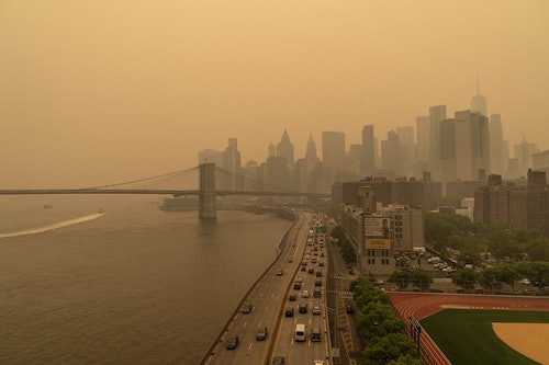
You can see a lot more from low Earth orbit. New York City looks more like the right now: hazy and surreal beneath a dim orange sky. in Quebec blankets much of the northeastern U.
S. in a layer two miles thick, according to measurements from NASA laser instruments on the ground. Those instruments, and a in low-Earth orbit, are monitoring the smoke as it spreads, and they’ve learned something surprising.
Just like rock layers record Earth’s geological history, layers of smoke in the giant plume record a much more ephemeral history of this year’s Canadian wildfires. The layer of smoke closest to the ground towers two miles into the atmosphere before it gives way to relatively clear skies. About four miles up, a thinner layer of smoke hovers above it.
And about 7. 5 miles above the ground, a very faint layer is all that’s left of fires in Alberta, in western Canada, in May. This image from the Geostationary Operational Environmental Satellite 16 (GOES-16) shows the smoke plume from above on the morning of June 7.
“There are different histories to each one of those layers that would be interesting to untangle,” says National Oceanic and Atmospheric Administration atmospheric scientist Michael Fromm in . Smoke from western Canadian wildfires often blows over the northeastern U. S.
, but by the time it’s traveled across the continent, it’s risen to such a high altitude that it goes largely unnoticed by people on the ground. But Quebec, in eastern Canada, is only about 500 miles from New York City, so the smoke is still much lower to the ground. That’s not helped by a stubborn area of low atmospheric pressure off the southeastern coast of Canada, which is drawing the smoke right across densely populated areas of the northeastern U.
S. We have that information about the smoke plume partly thanks to two networks of lidar instruments, which use lasers to measure the distance to objects or surfaces, like cloud layers. The ground-based Micro-Pulse Lidar Network (MPLNET) and the satellite CALIPSO (Cloud-Aerosol Lidar and Infrared Pathfinder Satellite Observation) are both helping measure the height of different layers of smoke.
NASA’s Goddard Space Flight Center in Greenbelt, Maryland, lies under the same stifling blanket of smoke as the rest of the northeastern U. S. We tend to picture smoke in shades of gray, so what’s with the eerie orange cast to northeastern skies? “Smoke particles scatter and absorb shorter wavelengths of sunlight like blues, greens, and yellows more easily compared to the longer-wavelength oranges and reds,” says NASA atmospheric scientist Ryan Stauffer in a recent statement.
In other words, the smoke acts like a really awful Instagram filter that only lets the longest wavelengths of light — reds and oranges –— through. The same principle is why the James Webb Space Telescope can see through cosmic clouds of dust by looking at the even longer wavelengths of infrared light, which can pass through clouds that trap shorter wavelengths. A trip of NASA satellites called Terra, Aqua, and Aura are measuring how the different layers of smoke affect how much — and which wavelengths of — sunlight Earth’s atmosphere absorbs and reflects.
.
From: inverse
URL: https://www.inverse.com/science/nasa-satellites-show-us-how-complex-the-canadian-wildfire-smoke-is


