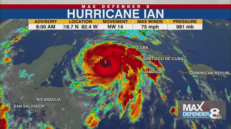
TAMPA, Fla. (WFLA) — Ian strengthened into a hurricane on Monday morning and is forecast to rapidly intensify into a major hurricane as it nears Western Cuba Monday night, the National Hurricane Center said. How to find your evacuation zone Much of the Tampa Bay area, including Hillsborough, Pinellas, Sarasota and Manatee counties, is under a Hurricane Watch, according to the NHC.
This means those in the area could see hurricane conditions (maximum sustained winds of 74 mph or higher) in the next two days. The watch is typically issued 48 hours before the anticipated first occurrence of tropical-storm-force winds, the NHC said. There is also a storm surge watch in effect for much of the area, which could see 5 to 8 feet of storm surge in over the next 48 hours.
At 8 a. m. Monday, Ian was centered about 90 miles west-southwest of Grand Cayman and 275 miles southeast of the western tip of Cuba.
Both areas are under hurricane warnings at this time, according to the center. The advisory showed Ian had maximum sustained winds of 75 mph. It was moving northwest at 14 mph, with hurricane-force winds extending outward up to 15 miles from the storm’s center.
Ian is expected to near the Cayman Islands on Monday, then strengthen into a major hurricane when it nears Western Cuba Monday night. The center said it will produce significant wind and storm surge impacts in that area. The forecast track shows Ian emerging over the southeastern Gulf of Mexico as a Category 4 hurricane on Tuesday, according to Storm Team 8 Meteorologist Leigh Spann.
The hurricane center said it will likely pass west of the Florida Keys late Tuesday, and approach the west coast of Florida on Wednesday. It’s still unclear exactly how the storm will impact the Gulf Coast. If it takes a more eastern track, the area could see 5 to 8 feet of storm surge or higher.
The strongest winds occur near the coast or the center of the storm, according to Storm Team 8 Meteorologist Amanda Holly. Florida emergency officials urge new residents to take approaching storm seriously The water could reach the following heights above ground in specified areas: Anclote River to Englewood (5 to 8 feet)Englewood to Bonita Beach, including Charlotte Harbor (4 to 7 feet)Bonita Beach to East Cape Sable (3 to 5 feet)East Cape Sable to Card Sound Bridge, including Florida Bay (2 to 4 feet)Florida Keys including the Dry Tortugas (2 to 4 feet) The storm could dump 8 to 10 inches of rain on portions of Central West Florida with some areas seeing isolated amounts of 15 inches, the NHC said. If it takes the more western track, the Tampa Bay area could still see some storm surge, but not as significant, along with 4 to 8 inches of rainfall, and a few tornadoes, Holly said.
The following watches and warning are in effect at this time. A Hurricane Warning is in effect for: Grand CaymanCuban provinces of Isla de Juventud, Pinar del Rio, and Artemisa A Tropical Storm Warning is in effect for: Cuban provinces of La Habana, Mayabeque, and MatanzasLower Florida Keys from Seven Mile Bridge westward to Key WestDry Tortugas Tampa Bay area school closures and cancellations A Storm Surge Watch is in effect for: Florida Keys from the Card Sound Bridge westward to Key WestDry TortugasFlorida BayAnclote River southward to the Card Sound Bridge,Tampa Bay A Hurricane Watch is in effect for: Englewood to the Anclote River, including Tampa Bay A Tropical Storm Watch is in effect for: Little Cayman and Cayman BracEnglewood southward to Chokoloskee Other areas to watch The NHC is also monitoring a broad area of low pressure in the Atlantic off Africa. The system has a 40 to 50% chance of becoming a tropical depression sometime this week.
The center issued its final advisory on Tropical Storm Gaston, which dissipated early Monday. .
From: kron4
URL: https://www.kron4.com/news/national/8-a-m-update-hurricane-ian-forecast-to-become-major-storm-near-cuba/


