FAYETTEVILLE, Ark. (KNWA/KFTA) — Traveling this weekend for Christmas? Well, you’re probably going to want to bring an umbrella because most of the United States will be seeing a good amount of rain over the next couple of days. Spotty showers during the day on Thursday is just the beginning of rain chances around our coverage area.
Thursday night of the 21st is our first real downpour. The rain chances tick up overnight Thursday into Friday morning of the 22nd and dwindling down by the afternoon leaving behind cloudy skies. This is what radar could look like through Friday early afternoon.
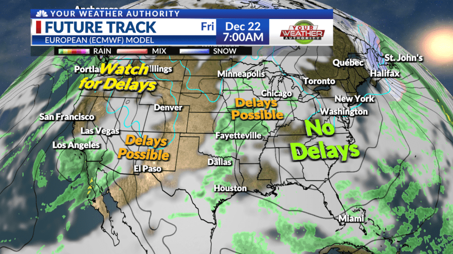
The good thing is that models have been too slow, so it could be out of here even sooner. Flying across the country on Friday? Well, it looks to be great across most of the country besides the Desert Southwest where a big churning low will be progressing its way through the area, so delays are possible. Now diverting to the Pacific NW, less of a chance for delays, but still, a good amount of rain is expected.
Up to the midwest, more specifically towards Chicago, some energy and a lot of rain are expected to bring delays. Not a whole lot of rain expected, just mainly cloudy skies and maybe some drizzle or mist here and there. Satellite/Radar is expected to look much like the image below for most of the day.
Good day to travel, especially by car, to your Christmas destination. Overnight Saturday night is where we get our next round of moderate to heavy rain. It’ll be a great day to travel to anywhere between the South Central Plains and the Southeast United States.
However, the same can’t be said for the Four Corners Region. The Rockies are going to be getting some snow on Saturday, so delays are likely. Delays in the NE aren’t as likely, but possible since they could see some winter precip.
As early as 1:00 AM CST we could see some moderate to heavy rain coming through. Here’s what the future track could look like. There does seem to be a break after 1 PM CST which seems good for travel, but other than that it’s a pretty soggy day.
Things will change in the evening though. Heavy rain and possibly some rumbles of thunder will be making their way through our area. Most of the nation’s midsection will likely see some delays if you’re leaving or departing from here.
The East Coast is fine, but will have that system making its way out there soon. The West Coast also seems mostly free of delays, besides the Pacific NW. Some heavy rain starting off the big day might be able to squeeze out a snowflake or 2 in the far Northern Portions of our coverage area, as you’ll see in snapshots in the future track.
While there won’t be a white Christmas morning, some wrap-around precipitation could be of the winter type if the air is cold enough. Temperatures at the surface look to be above freezing, so no snow accumulation is expected, but it wouldn’t be a bad day to end Christmas for winter weather lovers of NWA. This big system will be making travel impacts across most of the Midwest extending into the Ohio River Valley down towards the Southeast.
Little to no travel delays west of the Rockies, but what about the day after? Besides the Midwest, most of the country seems to be free of travel delays. That’s going to do it for this weather blog. Safe travels! Have a very merry Christmas from Your Weather Authority Team.
: To make sure you are staying up-to-date with the forecast, download the YOUR Weather Authority app to get updates anywhere at any time. .
From: nwahomepage
URL: https://www.nwahomepage.com/news/featured-stories/christmas-weekend-travel-outlook/


