TAMPA, Fla. (WFLA) — As two named storms swirl around in the Atlantic, forecasters are tracking three more systems, including a wave that could become a tropical depression and reach the Gulf of Mexico soon. After wreaking havoc across the Caribbean, Fiona, the first major hurricane of the season, is heading north-northeastward toward Bermuda, while Tropical Storm Gaston, the other named storm, hangs a few hundred miles off the coast of the Azores.
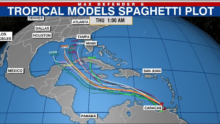
Where will Invest 98L go after it forms? Gulf Coast forecasters are keeping a close eye on Invest 98L. The disturbance has a high 70% chance of becoming a tropical depression or storm over the next two days. Here’s what to know.
Hurricane Fiona At 5 a. m. Thursday, Fiona was about 485 miles southwest of Bermuda with maximum sustained winds of 130 mph, making it a Category 4 hurricane.
It was moving north-northeast at 13 mph with hurricane-force winds extending outward up to 70 miles from the storm’s center. Fiona is forecast to pick up speed as it moves north-northeastward toward Bermuda, and will pass just west of the island Thursday night. Little change in strength is expected through Thursday night.
It should near Nova Scotia by Friday and move into the Gulf of St. Lawrence on Saturday. It will still be producing hurricane-force winds this weekend after it becomes post-tropical, the NHC predicted.
Fiona could dump 1 to 4 inches of rain on parts of Bermuda, Nova Scotia, Prince Edward Island, western Newfoundland, Eastern Quebec and Eastern New Brunswick. 2022 Hurricane Guide: Prepare your family before a storm It’s not expected to threaten the U. S.
mainland, but swells from the storm will continue to spread toward the multiple Caribbean countries and the east coast of the U. S. and likely reach Bermuda Thursday morning.
The swells could cause life-threatening surf and rip current conditions in Bermuda, the NHC said. A Hurricane Warning is in effect for Bermuda. Invest 98L A disturbance dubbed Invest 98L has a 70% chance of developing into a tropical depression sometime in the next two days, and a 90% chance of developing over the next five days.
The disturbance is over the far southeastern Caribbean Thursday morning. It is forecast to move west-northwestward across the eastern Caribbean and should be over the central Carribbean this weekend. Forecasters say the Windward Islands will see heavy rain and gusty winds on Thursday morning, and those conditions will likely spread to parts of Venezuela, Colombia and the ABC island chain over the next couple days.
6 years after Hurricane Hermine, could Florida see another storm with same name? Forecast models show a depression forming south of Jamaica over the weekend and moving into the Gulf of Mexico by the middle of next week. Storm Team 8 Meteorologist Rebecca Barry predicts there will be a system in the Gulf by the middle of next week, but said it was too soon to tell where it will make landfall. “Forecast models typically perform poorly when the system’s not formed yet,” Barry explained.
“When that center forms to the south of Jamaica, we’ll get much better and much more accurate long-range forecasts. ” It could grow stronger if it winds up between Mexico and Cuba. “We know interaction with land can weaken tropical systems and sometimes change their path, so that’s an area that remains a question in the forecast – how will it survive the passage if that’s the path it takes?” Barry said.
“We do expect it to develop this weekend. And there’s nothing really standing in its way,” she added. “We talk about moisture, sea surface temperatures and shear as big factors to inhibit systems from developing and this system has no problem with those.
” Tropical Storm Gaston At 5 a. m. , Tropical Storm Gaston was about 375 miles west-northwest of Faial Island, Azores, with maximum sustained winds at 65 mph.
It was moving east-northeast at 17 mph with tropical-storm-force winds extending outward up to 60 miles from the storm’s center. Gaston is expected to turn to the east Thursday night before it slows down and starts heading south. It will likely be near the coast of the Azores on Friday.
3 Florida roads among worst traffic spots in US Swells from Gaston are expected to affect the Azores Thursday and may cause life-threatening surf and rip current conditions, the NHC said. Other areas to watch The hurricane center is also monitoring a tropical wave located several hundred miles west-southwest of the Cabo Verde Islands. It has a low 30% chance of becoming a tropical depression or storm over the next five days.
There is another tropical wave that’s set to move off the west cost of Africa. It has a 60% chance of becoming a tropical depression or storm over the next five days. Tracking the Tropics streams at 2 p.
m. ET every Wednesday during hurricane season. For the latest updates, check out our Tracking the Tropics website.
.
From: wfla
URL: https://www.wfla.com/weather/tracking-the-tropics/hurricane-fiona-heads-to-bermuda-gulf-coast-watches-wave-to-the-south/


