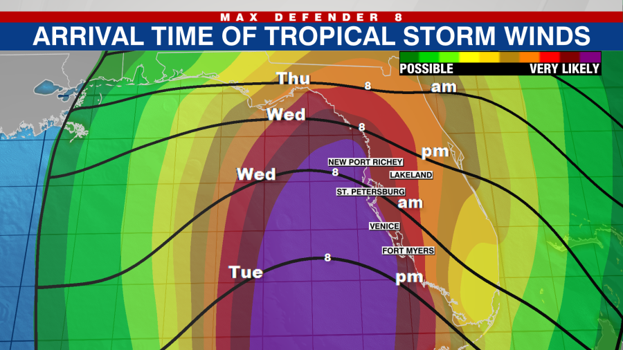
TAMPA, Fla. (WFLA) — All eyes are on the Gulf of Mexico as Hurricane Ian moves over warm water on its trek toward Florida. The latest forecast track shows Ian move into the Gulf of Mexico Tuesday and approach Florida’s west coast Wednesday into Thursday.
“The forecast track didn’t shift so much but the forward motion has slowed down and that’s certainly not something that we want to see because that prolongs those heavy, strong rain bands that come through. It prolongs the flooding potential from the storm surge,” WFLA Meteorologist Leigh Spann said. “We’re looking at more than a 48-hour spread from when we begin to see these tropical conditions to when we finally start them ease up,” she added.
Here’s when Tampa Bay could potentially start seeing impacts and what to expect: Tuesday night Northern rain bands will start to bring brief periods of gusty winds and tropical heavy rains as early as Tuesday afternoon and evening. As the night goes on, the steady heavy rain will move up from the north and the winds will steadily increase. Wednesday morning By Wednesday morning, off and on sustained tropical storm force winds are more than likely for areas along the coast in Pinellas County and areas south.
More frequent rain bands will be moving through but there will still be dry and less gusty periods of time in the morning. By midday, the winds will get stronger and stay stronger for longer as the storm gets closer. Most people in the Tampa Bay area should be sheltered in place at this time and be ready for two solid days of continuous impacts.
There will still be an offshore wind at this time actually pushing water out of bays and rivers leading to lower than normal tides so storm surge will not be be an issue, yet. There is a low chance for isolated tornadoes in these northern rain bands moving through. Wednesday night Ian will be approaching the west central Florida coastline, likely as a major Category 3 hurricane.
The worst of the weather will be settling in. Sustained tropical storm-force winds along with frequent hurricane gusts will be well underway for Sarasota, Manatee, Pinellas and Hillsborough counties. There will be tropical storm (39 to 74 mph) force gusts with occasional sustained tropical storm-force winds inland by Wednesday evening as well.
Water from the Gulf of Mexico will begin to inundate Sarasota Bay, the Manatee River and somewhat into Tampa Bay for elevated tide levels. Isolated tornadoes will be possible in the rain bands that move through. This will be possible through Friday.
Thursday morning The worst of the weather will continue through Thursday midday before conditions begin to slowly improve Thursday night and Friday morning. Hurricane-force winds will continue along the coast and the storm surge will be highest during the early Thursday high tide. Storm surge forecasts are calling for seven to 10 feet of water above the regular high tide levels.
While the storm will be a little weaker by this time, trees and structures could be weaker due to the prolonged nature of the storm’s impacts. Improving conditions If Ian hasn’t made landfall along the Manatee/Sarasota or Pinellas County coastline yet, the storm will be weaker approaching the Nature Coast or the Big Bend Friday morning. Conditions will improve with less frequent wind gusts, fewer rain bands and water levels receding from storm surge.
Flooding from heavy rains could linger with the saturated grounds. Rivers will continue to rise with several not cresting until the weekend. All that being said – by Friday, the hurricane conditions will be over.
.
From: wfla
URL: https://www.wfla.com/weather/tracking-the-tropics/hurricane-ian-timeline-when-tampa-bay-could-start-feeling-impacts/


