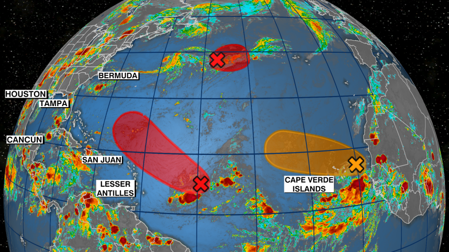
TAMPA, Fla. (WFLA) — Activity is ramping up in the Atlantic as we head into September and get closer to the statistical peak of hurricane season, and the National Hurricane Center says it’s likely at least one of the three disturbances it’s tracking will develop this week. The Atlantic basin saw a long stretch of little to no activity for about the past two months.
According to Dr. Philip Klotzbach, a meteorologist with Colorado State University, this year marked the first time since 1941 that there were no named storms in the Atlantic from July 3 through Aug. 30.
The last named storm in the Atlantic was Tropical Storm Colin, which formed over South Carolina on July 2. The NHC says it’s likely at least one of the three disturbances meteorologists are monitoring – Invest 91L, Invest 93L and an area of low pressure off the coast of Africa – will become a tropical depression later this week. Invest 91L The NHC has been monitoring Invest 91L all week, and it’s the main disturbance meteorologists are keeping an eye on because it has the highest chance of formation.
As of Wednesday, the NHC gives it a medium 60 percent chance of formation in 48 hours and a high 80 percent chance of formation through the next five days. Invest 91L is an area of low pressure that’s associated with showers and thunderstorms several hundred miles east of the Lesser Antilles. The NHC says gradual development is forecast in the coming days despite environmental conditions being only “marginally conducive.
” A tropical depression will “likely” form from Invest 91L later this week. “It will possibly become our next named storm but the forecast models have it recurving even before it makes its way to the Bahamas,” WFLA Meteorologist Amanda Holly said. “That’s what we want to see this time of year.
So even if it does become our next named storm, it won’t affect us. ” Invest 93L The NHC started tracking Invest 93L on Wednesday. The disturbance is described as an “area of low pressure.
. . along a decaying frontal zone” over the central Atlantic, about 850 miles southwest of the Azores.
According to the NHC, environmental conditions appear favorable for some development. A tropical weather outlook released Wednesday morning says a tropical or subtropical depression will likely form later this week as the system moves toward the east. The NHC has given Invest 93L a medium 60 percent chance of formation in 48 hours and a high 70 percent chance of formation in the next five days.
Disturbance The tropical wave that emerged off the coast of Africa earlier this week is now a broad area of low pressure associated with showers and thunderstorms between Africa’s west coast and the Cabo Verde Islands. The NHC has not deemed the disturbance an invest yet. According to the NCH, the disturbance appeared slightly more organized on Wednesday and a short-lived tropical depression could form over the eastern Atlantic this week.
By later this week, however, environmental conditions will be less favorable for development. The NHC has given the disturbance a medium 40 percent chance of formation through 48 hours and a medium 50 percent chance of formation through five days. Looking ahead If one of the disturbances being monitored in the Atlantic becomes a named storm, it will get the name Danielle.
It’s likely we’ll continue seeing an uptick in tropical activity moving forward as we get into the month of September. The statistical peak of hurricane season is on Sept. 10.
Roughly two-thirds of all tropical systems in the Atlantic basin form in August or September. .
From: wfla
URL: https://www.wfla.com/weather/tracking-the-tropics/tracking-the-tropics-development-expected-this-week-after-nearly-2-months-of-no-storms/


