TAMPA, Fla. (WFLA) — As Hurricane Fiona continues to batter islands in the Atlantic, and Tropical Depression Eight forms, forecasters with the National Hurricane Center and U. S.
meteorologists are keeping a close eye on a tropical wave moving west toward the Caribbean Sea. 2022 Hurricane Guide: Prepare your family before a storm You may have already seen a post on social media of a long-range forecast showing a hurricane heading into the Gulf of Mexico and making landfall along the Florida coast. That is the reason meteorologists are watching the area of disturbed weather that has not yet developed.
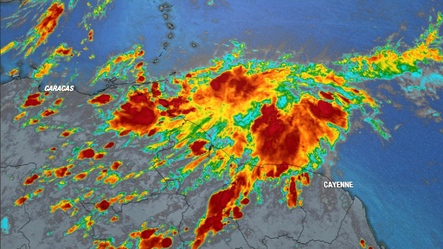
However, it is far too soon to tell where the potential system may end up. What we know right now The tropical wave is several hundred miles east of the Windward Islands and started to look a little more organized on satellite imagery Tuesday. It will most likely continue to organize and become a tropical depression later this week.
Tropical wave expected to develop over the next 5 days. It’s moving fast – for a tropical system – toward the west-northwest, at about 15 to 20 mph. As of Tuesday, the NHC gives the wave a 70% chance of developing over the next five days.
As it moves to the south of Puerto Rico, it will be over very warm sea surface temperatures and low wind shear, both of which are favorable for further organization and strengthening. Sea surface temperatures south of Hispaniola are in the 90s and the wind shear is low. The two major long-term forecast models both predict the system will move into the Gulf of Mexico.
The GFS (pictured in green below) shows the system crossing over Cuba next Wednesday morning. We know interaction with land can weaken tropical systems and sometimes change their path, so that’s an area that remains a question in the forecast – how will it survive the passage if that’s the path it takes? The Euro (pictured in red below) is a tad slower and shows a slightly more western path, passing between Mexico and Cuba. That path might make for a stronger system, although that is not what the Euro forecast predicts currently.
GFS (green) vs Euro (red) forecast entering the Gulf. Too early to tell The next part is what you’ve probably seen on social media posts – and what you should know is forecast models that predict this far out are often not correct. The forecast quality improves greatly once the system actually forms.
We often see big changes in what the long-range forecast models predict when the system actually forms. Data input, like where the actual center of the system is, and other factors can change the forecast greatly. The greater systems at play that help steer the storm in the Gulf also have not yet formed.
We will be watching an area of high pressure that is forecast to be roughly near the coastline of Virginia. Where that will be could be the difference between a Mississippi landfall vs. a Florida landfall.
Download the Max Defender 8 app We will get a better idea by the end of next week, once the system forms and the greater weather patterns across the United States become more clear. Right now, the GFS is predicting a Florida impact. Below, you can slide between the GFS and the Euro to compare the forecast for next Thursday, Sept.
29 to see how they are different. The Euro is on the left and predicts the system passing to the west of the coast of Florida, heading toward the western panhandle or near the Florida-Alabama border. The GFS actually updated while I was writing this- the previous model run pushed the system into Tampa Bay, the updated forecast now looks more like the Euro, heading in the general direction of the western Panhandle.
The GFS predicts a much more powerful storm with a slightly slower forward motion. Euro on the left, GFS on the right, slide to compare. Final thoughts In short – it is not time to panic.
We expect this to change over the next few days. I do think we will have a system in the Gulf by the middle of next week, but it is entirely too soon to tell where it will make landfall or how it may, or may not, impact our area. I think by the end of this week, we will have a much more accurate forecast for this system.
Close Thanks for signing up! Watch for us in your inbox. Subscribe Now Daily Weather Forecast SIGN UP NOW if ( window. checkSizeClasses && window.
checkSizeClasses instanceof Function) { window. checkSizeClasses(); }.
From: wfla
URL: https://www.wfla.com/weather/tracking-the-tropics/tracking-the-tropics-why-gulf-coast-meteorologists-are-keeping-close-eye-on-tropical-wave-in-atlantic/


