TAMPA, Fla. (WFLA) — The 2022 Atlantic hurricane season is heating up. The National Hurricane Center is currently monitoring two named storms swirling about in the Atlantic along with three other areas of interest.
After hitting the Turks and Caicos, Hurricane Fiona, the first major hurricane of the season, became a Category 4 storm on Wednesday morning, while Tropical Storm Gaston, the other named storm, grew stronger. Forecasters are also keeping a close eye on a tropical wave moving west toward the Caribbean along with two other disturbances. Here’s what you should know.
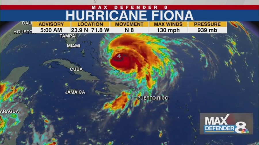
Hurricane Fiona At 5 a. m. Wednesday, Fiona was about 170 miles north-northwest of Grand Turk Island with maximum sustained winds of 130 mph, making it a Category 4 hurricane.
It was moving north at 8 mph with hurricane-force winds extending outward up to 45 miles from the storm’s center. The forecast track shows the storm moving away from the Turks and Caicos on Wednesday and turning toward the north-northeast and approaching Bermuda late Thursday. Why Gulf Coast meteorologists are keeping close eye on tropical wave in Atlantic Forecasters say the storm may fluctuate in intensity Wednesday night and on Thursday, and tropical storm conditions could reach Bermuda by late Thursday.
The storm is expected to dump 1 to 4 inches of rain on parts of the Dominican Republic, Turks and Caicos, Southeast Bahamas and Bermuda. It’s not expected to threaten the U. S.
mainland ,but swells from the storm will continue to spread toward the Bahamas and the east coast of the U. S. and likely reach Bermuda Thursday.
The swells could cause life-threatening surf and rip current conditions in Bermuda, the NHC said. A Tropical Storm Watch is in effect for Bermuda. Tropical Storm Gaston At 5 a.
m. , Tropical Storm Gaston was about 850 miles west of the Azores with maximum sustained winds at 65 mph. It was moving northeast at 16 mph with tropical-storm-force winds extending outward up to 70 miles from the storm’s center.
Gaston is forecast to turn to the northeast Wednesday, then toward the east on Thursday. It could grow stronger Wednesday, but is forecast to weaken later, and is not expected to become a hurricane. Swells from the storm could hit the Azores later in the week, and cause life-threatening surf and rip current conditions, the NHC said.
Tropical wave in the Atlantic The NHC says a tropical wave in the western tropical Atlantic has a 70% chance of developing into a tropical depression in the next two days. The disturbance is currently located a few hundred miles east of the Windward Islands and has continued to show signs of organization, according to the center. The system is expected to move toward the Caribbean later this week, and some forecast models show it reaching the Gulf of Mexico.
2022 Hurricane Guide: Prepare your family before a storm Storm Team 8 Meteorologist Rebecca Barry predicts there will be a system in the Gulf by the middle of next week, but it’s too soon to tell where it will make landfall. Other areas to watch The hurricane center is monitoring a tropical wave located several hundred miles west-southwest of the Cabo Verde Islands. It has a low 20% chance of becoming a tropical depression or storm over the next five days.
There is another tropical wave that’s set to move off the west cost of Africa. It has a 50% chance of becoming a tropical depression or storm over the next five days. .
From: wfla
URL: https://www.wfla.com/weather/tracking-the-tropics/tropics-heat-up-hurricane-fiona-is-cat-4-gaston-strengthens-gulf-coast-keeps-eye-on-tropical-wave/


